


You can keep your Pacific Coast Highway selfies. The real flex among road trip obsessives is casually dropping, over a glass of wine, that you have driven the Beartooth Highway, often called the “most beautiful roadway in America”. It is the kind of phrase that sounds like brochure hyperbole until you see how quickly people’s eyes light up when they have actually been.
The catch is that this 68 mile strip of US Route 212, straddling Montana and Wyoming between Red Lodge and Cooke City–Silver Gate at Yellowstone’s Northeast Entrance, spends most of the year buried under snow. For a sliver of late spring to fall, though, it becomes a high-altitude runway where forests, cliffs, tundra, lakes, and wildlife all fight for your attention, and where your phone camera roll will absolutely give up.
Where Exactly Is This So-Called Most Beautiful Roadway
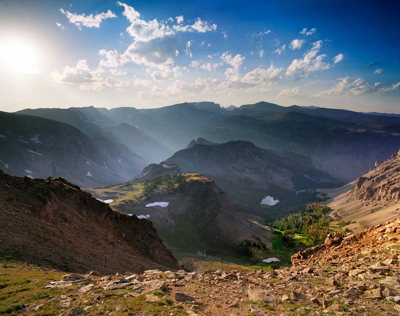
On a map, the Beartooth Highway looks deceptively simple: a crooked line between the small town of Red Lodge, Montana and the tiny outpost of Cooke City–Silver Gate, the back door into Yellowstone National Park. In reality, it climbs from the valley floor to Beartooth Pass at 10,947 feet above sea level, brushing the Absaroka–Beartooth Wilderness and threading between Custer Gallatin and Shoshone National Forests before dropping into Yellowstone country again.
That altitude is not just cocktail party trivia. It makes Beartooth the highest-elevation highway in both Montana and Wyoming, and the highest in the Northern Rockies. The route is officially designated a National Scenic Byways All-American Road, which is Washington-speak for “you would travel here just for this drive”. Legendary CBS correspondent Charles Kuralt once called it “the most beautiful drive in America”, a line that stuck so hard it shows up in federal documents about the road itself as “the most beautiful roadway in America”. No pressure.
Why Beartooth Highway Lives Up to the Hype
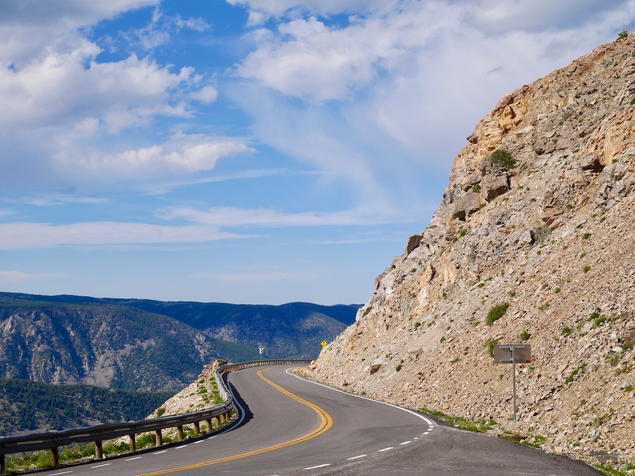
Most scenic drives ease you into the drama. Beartooth is not that polite. Leaving Red Lodge, you are almost immediately into a series of tight switchbacks that climb above the Rock Creek canyon. One minute you are in a pine forest, the next you are looking down on entire valleys, the road you just drove now a toy ribbon far below. It feels more like taking off than driving, especially if you are used to city commutes and sensible speed limits.
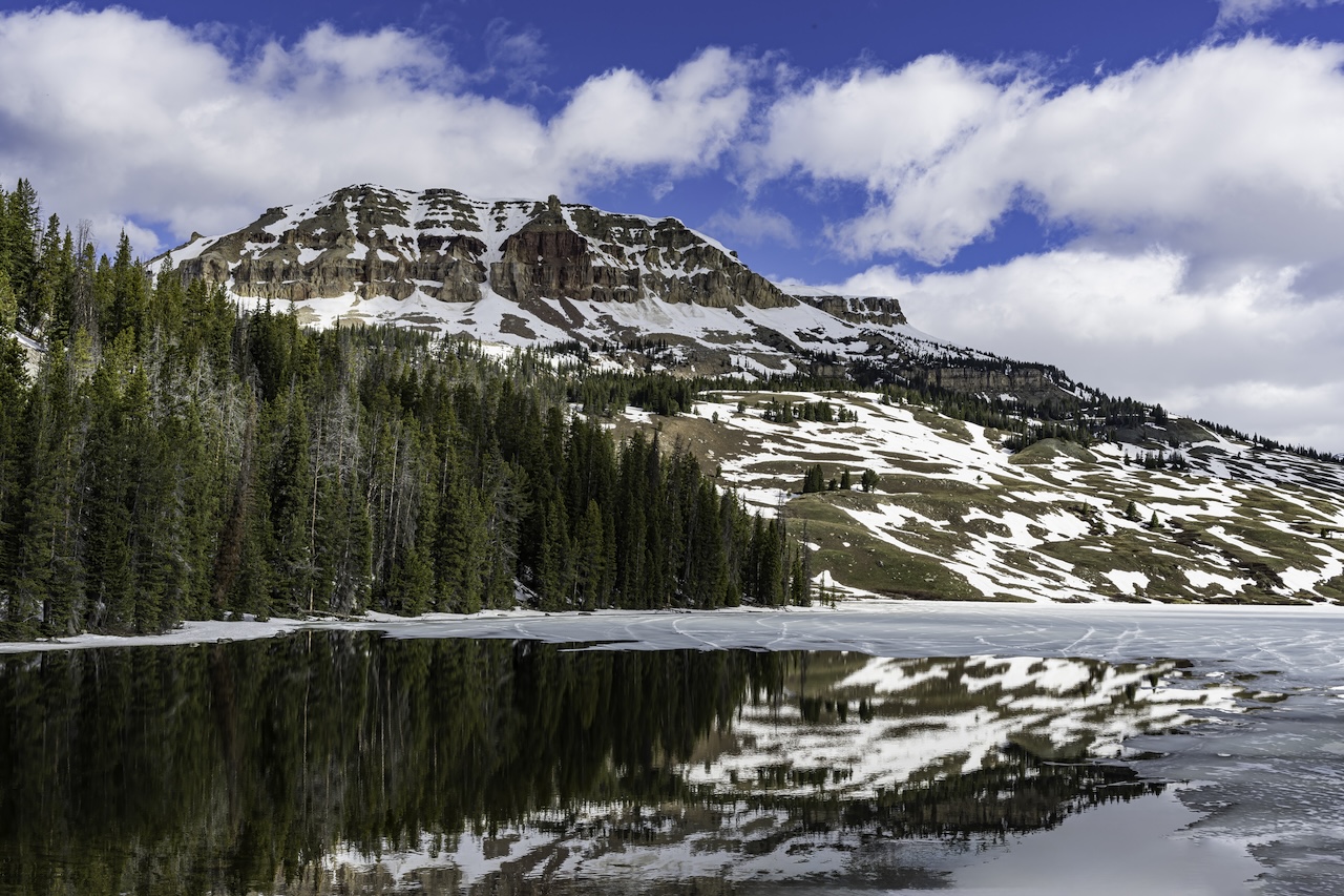
By the time you hit the plateau near Beartooth Pass, you have entered a different world. The trees thin out, replaced by alpine tundra and scattered snowfields even in July. Glacially carved lakes appear on both sides of the road like a string of turquoise sequins: Island Lake, Beartooth Lake, Twin Lakes, and more, all begging for you to pull into a turnout and “just take a quick look” that somehow becomes a forty-minute wander.
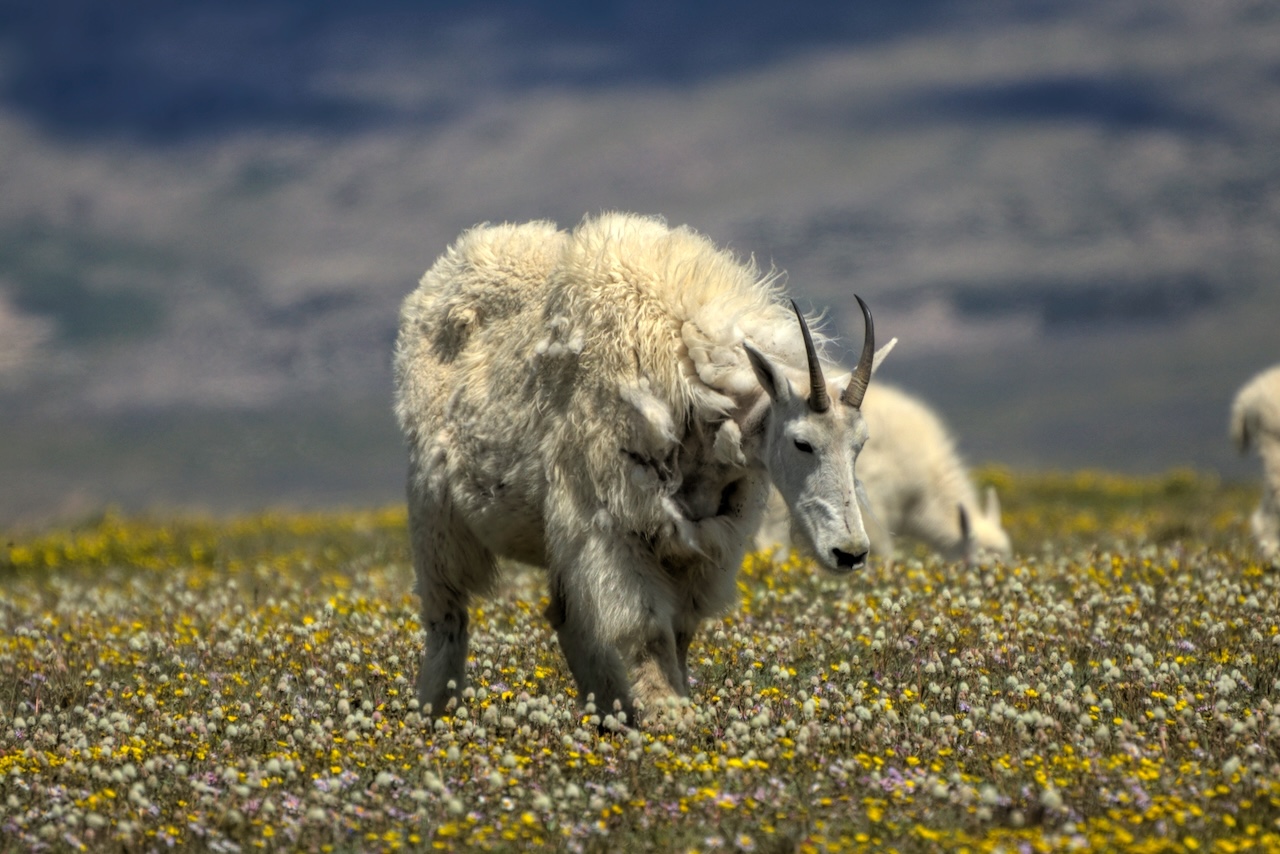
Locals like Red Lodge shop owner Marci Dye talk about how the wildflowers up here flip palettes every few weeks, so a late June visit looks nothing like early August. She also points out that you can usually find at least one lingering snowbank in high summer, which is deeply entertaining if you have never made a snowball in shorts. Mountain goats often graze close to the road, unbothered by photographers and iPhones, and, with luck, you might spot a moose, a distant bear, or elk threading the meadows. This is real wilderness, not a drive-through safari; the animals are living their lives, and you are the guest.
Then there are the quirks that feel almost surreal. A tiny ski area, Beartooth Basin, operates on lingering snow most years in June, so you can be on a hot-weather road trip, sunglasses on, watching people lap a chairlift in full winter gear. The “rustic and one-of-a-kind” Top of the World Store sits at roughly 9400 feet, selling fuel, snacks, and souvenirs at a point where you would swear no such thing could exist. It is all a little bit extra, in the best way.
Part of the magic is scarcity. The highway typically opens around Memorial Day and closes again by mid-October, but that window is aspirational, not guaranteed. Early and late season snowstorms can shut it for a day or three with almost no warning, and afternoon thunderstorms in June or September may erase blue skies in minutes with hail and sleet. Clear, calm days feel like something you scored rather than something you booked.
How to Actually Drive It Without Losing Your Nerve
If you are trying to time this right, think less about dates on a calendar and more about probabilities. July and August are the sweet spot for most travelers. In early to mid July, you get wildflowers at their peak plus plenty of leftover snow. By late summer, the weather is generally more stable, though high country storms are always a possibility. Opening and closing dates change every year, so treat them as rumors until you have checked the Montana and Wyoming transportation sites the week you go.
Time of day matters almost as much as the month. Sunrise from the Red Lodge side gives you quiet roads and that rose-gold alpenglow on jagged peaks that no filter can fake. Late afternoon into golden hour is gorgeous on the high plateau and around the lakes, when the wind often drops, and the water turns into a mirror. Midday works better if you are traveling with kids or anyone nervous about mountain driving, since visibility is better and you are less likely to hit an afternoon storm up high. Either way, “give yourself the whole day, not ninety rushed minutes,” locals say.
A simple, chic itinerary looks like this: wake up in Red Lodge, grab coffee and something you can eat one-handed, then start climbing before traffic builds. Stop at Rock Creek Vista Point to stretch and stare straight into the canyon. Wind your way to Beartooth Pass for the true top-of-the-world moment, then drop down to wander around Island Lake or Beartooth Lake on short, easy trails. Check out Beartooth Basin if it is operating, refuel at Top of the World Store, then continue toward Clay Butte Lookout or, if that road is closed, the Yellowstone Overlook with its famous views of Pilot and Index Peaks. End in Cooke City–Silver Gate and, if you have the energy, roll a little farther into Lamar Valley for sunset wildlife watching.
Preparation is less glamorous but completely non-negotiable. Up top, it can be 20 to 30 degrees cooler than in Red Lodge, with wind that cuts through cute denim jackets. Pack layers, a really warm coat, gloves, a hat, and a rain shell, even in peak summer. Bring water, snacks, sunscreen, and sunglasses; at nearly 11,000 feet, the sun has opinions. Motorcyclists need serious wind protection and should expect temperatures that feel more like late fall than July. Do not rely solely on navigation apps for closures; they are notorious for being wrong here. Stop in Red Lodge or Cooke City and ask an actual human about current conditions.
On the road, take the mountain pass commandments seriously. Drive the switchbacks slowly, use pullouts for photos, and never stop in the travel lane to grab a shot. If you see wildlife, stay in your car or keep a generous distance. As more than one ranger has put it, this is not a zoo. Treat the Beartooth Highway as the main event, not a side quest tacked onto an already epic Yellowstone day, and it will absolutely live up to its title as the most beautiful roadway in America.


